How to Hike the Prettiest Waterfall in Grand-Staircase Escalante
Scribbled by Claire ◊ 19 Aug 2024
Here, we provide all the information to help you plan your hike to the prettiest waterfall in Grand-Staircase Escalante, southern Utah – Lower Calf Creek Falls, including hiking tips, difficulty, parking, fees, water quality, camping and more.

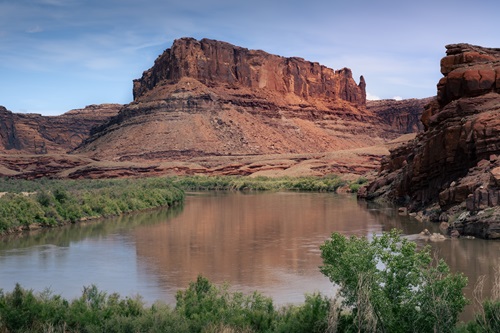
Hidden within the immense canyons and rock formations of southern Utah is a magnificent 126-foot-tall waterfall called Lower Calf Creek Falls.
Named for its use as a calf pen in the late 1800s, this waterfall really delivers bang for your buck; the hike is beautiful and not too difficult, with fewer tourists than in nearby Bryce Canyon, and the setting for the falls is spectacular! Hiking Lower Calf Creek Falls should be right at the top of anyone’s southern Utah road trip itinerary.
For more information on the surrounding region, consider checking out our detailed post on things to do around Escalante, Utah.

IN THIS GUIDE //
How to Hike the Best Waterfall in Escalante, Utah
WHY HIKE LOWER CALF CREEK FALLS?
WHERE IS LOWER CALF CREEK FALLS TRAILHEAD?
BEST TIME TO VISIT CALF CREEK FALLS
LOWER CALF CREEK FALLS – A MAP
HOW DIFFICULT IS THE TRAIL?
LOGISTICS AND OTHER INFORMATION
WHERE TO STAY NEAR CALF CREEK FALLS
FEES FOR LOWER CALF CREEK FALLS
WHAT TO BRING FOR THE HIKE
CAMPING NEAR CALF CREEK FALLS
OTHER ACTIVITIES NEAR CALF CREEK FALLS
FINAL THOUGHTS
This post may contain affiliate links. If you book through these links we may make a small commission at zero cost to you. It helps us pay for the upkeep of this blog. Thank you!
Why Hike to Lower Calf Creek Falls
The Lower Calf Creek Falls trail follows a miles-long creek along the bottom of a soaring canyon, to a 130-foot-high waterfall that cascades over the end of the valley. It’s one of the most beautiful sights I’ve ever seen at the end of a hike!
If that isn’t enough, here are a few more reasons to hike this trail:
Affordable | $5 parking fee, or free with an America the Beautiful pass
Elevation | very little change, so is perfect for people of lower fitness levels
Scenic | the whole trail is pretty, not just the famous waterfall
Location | Calf Creek Falls is nearby to the adventure-centre of Escalante, which has a plethora of things to do
Pets | this trail is pet-friendly, so bring your leashed friend along for the ride
Kids | this hike has petroglyphs and things to spot, which is perfect for kids (and adults)
Where is Lower Calf Creek Falls?
This trail is located in Grand-Staircase Escalante National Monument, a huge region in southern-central Utah. The enormous national monument covers more than 1.8 million acres and contains some of the most inaccessible and distinctive land in the country.
Lower Calf Creek Falls trailhead is located on the left, just off Utah Scenic Byway 12, when travelling between the small towns of Escalante and Boulder. Parking is available a short distance down the gravel road which is suitable for two-wheel drive cars and has clear signage. The lot is accurately marked on Google Maps.

CAR HIRE FOR YOUR SOUTHWEST ITINERARY
We always rent our vehicles all over the world, including our recent trip in the United States, with Discover Cars. They’re often the most affordable, plus they paid out immediately on an insurance claim we made when our car took some heavy damage in Sicily. We fully recommend them.
–
TAKE A LOOK BELOW OR CHECK CAR RENTAL
Best Time to Visit Lower Calf Creek Falls
There are two factors to consider when planning your trip to Calf Creek falls: the weather and the crowds.
Although the national monument is huge, it does not receive anywhere near as many visitors as nearby Bryce Canyon and Zion National Parks. However, Lower Calf Creek Falls is one of the most popular attractions in the region and ease of access means it still gets busy (it was busy both times we hiked it in fall and spring).
Visit mid-week | this helps to avoid the crowds; earlier in the day is better, too. Last time we were there on a weekday around 8am in October, there was only one other car in the lot. Returning around 11.30am, the lot was full, and people were waiting for spaces.
Spring and fall | April-June and September-November are the best choices when considering the weather. The conditions are mild and crowds are lower than during the summer holidays.
Hottest months | July and August have average highs of 31-33 C (90 F). These months are also the wettest due to the monsoon season. Do not attempt this hike if there is rain forecast – being caught in a canyon with flash flooding is dangerous and paths on this trail can get washed away.
Winter months | December, January and February have cold day time temperatures (below 10C, 50F) and freezing nights (not exactly favourable conditions for swimming or wading in a waterfall!). Crowds are thin, though, at this time of year. There are also less daylight hours, so plan accordingly. When weather is bad during the winter months, the roads, including Byway 12, can be icy due to the elevation. Consider if your car is appropriate for the conditions.
LOWER CALF CREEK FALLS HIKE – QUICK FACTS
PERMITS – Not required
PARKING – Located by the Trailhead
COST – $5 parking
WATERFALL HEIGHT – 126 feet
BEST SEASON – April-June and September-November
HIKE LENGTH – 6 miles, 3-4 hours
NUMBER OF CALF CREEK CAMPSITES – 13
ELEVATION CHANGE – 200 feet
–
AMAZING ADVENTURES IN KANAB, UTAH | THREE EPIC DAYS IN MOAB
Lower Calf Creek Falls – Map
Below is a savable Google Map for this Lower Calf Creek Falls post.
◊ Green relates to the Lower Calf Creek.
◊ Orange marks nearby accommodation
To view these sections, select the icon in the top left corner of the map.
To save the map, select the star next to the title.
LOWER CALF CREEK FALLS – CURRENT CLOSURES
As per the BLM –
As of September 28th 2024, after around three months of site improvements, the Calf Creek Recreation Site is now open again.
Check the BLM Calf Creek webpage for updates on further planned works.
–
AMAZING ADVENTURES IN KANAB, UTAH | THREE EPIC DAYS IN MOAB

Is Hiking Lower Calf Creek Falls Difficult?
No, hiking Lower Calf Creek Falls is not difficult for anyone with average mobility. However, the hike length is on the longer side, the elevation is well above sea-level and the sun exposure can be another issue.
Trail type | the Lower Calf Creek Falls hike is an out and back, 6-mile roundtrip route which takes about 3-4 hours. It’s a beautiful hike, but I find out-and-back trails can drag on the way out.
Difficulty | the trail itself is easy, however the length and sun exposure can make this hike feel more strenuous than it is. There is a minimal elevation change of about 200 feet, but the sandy paths, slick rock and lack of shade can be tiring. There are no technical or steep/difficult sections on this hike.
Elevation | the trail elevation varies between 5350 and 5550 feet, which can come as a surprise to some. Although this will not give you altitude sickness, if you are a sea-level dweller like me, the air does feel a little thinner. Plan to potentially hike slower that you usually would.
Sand | sand is always a nightmare to hike on and the Calf Creek Falls has this in abundance! Just bear it in mind that the terrain can be a little slow going at times.
Exposure | there is significant sun exposure on this trail, especially earlier on in the hike. Towards the waterfall end of the trail, there are more trees and vegetation which provide shelter from the sun. The mist from the falls can make the air seem a little cooler in summer, too.
Fitness | you do not need to be particularly fit to complete this hike. It is a nice, approachable hike for people with minimal hiking experience because the path is clearly marked the entire way, and you’ll rarely be alone for a significant period. Ensure you go prepared and any able-bodied walker can reach the waterfall!
Other Fun Trail Information
Desert colours | the towering, cliff-bound canyon walls are shades of black and orange. The waterfall plunges over the sandstone cliffs which have a kind of streaky pattern or ‘desert varnish’. This is caused by a type of microbe that oxidizes iron and manganese from clay minerals. The darker stripes are from high manganese concentrations with humid conditions, and the orange stripes are where there is less manganese and more dry, arid conditions.
Trail booklet | at the beginning of the trail, there is a sign-in type book. Put your information in – this might help if you were to have an accident or get stuck. There is also a leaflet about the hike provided by the BLM. Along the route there are things like petroglyphs and granaries which date back to 700 CE. There are fifteen interpretive stops in total which are particularly fun if you are hiking with children.
Wildlife | the year-round creek means that despite the seemingly harsh rocky landscape, within the canyon there is a whole lot of life. Wildflowers can be spotted for most of the year. There are various birds living in the canyon, like hummingbirds, ravens, robins, and peregrine falcons. Other wildlife you might spot include lizards, deer, squirrels, and coyotes (though we mostly only saw other humans and their dogs).


TOXIC ALGAE BLOOMS IN LOWER CALF CREEK
The Utah Department of Environmental Quality has reported harmful algae bloom in the creek water at Lower Calf Creek Falls.
Algae blooms can sometimes be toxic, and when the algae grows excessively, these toxins can be very harmful to humans (sometimes referred to as cyanobacteria).
There was an update on the 1st of June 2024 requesting visitors stay away from any visible blooms and to keep pets away from the water.
For this reason, I wouldn’t personally drink from the creek, even with a filter.
–
Things to Know About the Calf Creek Falls Hike
Permits | there are no permits or passes required to do the Lower Calf Creek Falls hike.
Pet friendly | dogs are permitted on the trail, but you should keep them on a lead.
Facilities | there are no facilities along the trail or by the waterfall. Calf Creek Campground has potable water and there are decent bathrooms near the trailhead.
Arrive early | to get a parking space and to avoid the crowds. There is overflow parking available on the gravel road leading to the main parking area but be aware of the ‘no parking’ signs.
Shops | the nearest shops for groceries and essentials are a 20-minute drive north to Boulder (very basic facilities) or 23 minutes south/east in Escalante which has more options. Stock up on everything you need before you arrive.
Gas | Gas can be found in Boulder and Escalante (more affordable in Escalante).
Swimming | this is allowed in the pool and creek, but ensure you wear environmentally-friendly sunscreen (the best option is just to cover up). Also, avoid putting your head under the water, as per the algae bloom situation mentioned above.
Escalante Interagency Visitor Centre | this is a useful stop for all up-to-date information pertaining to trail, road and campground conditions. They also provide practical advice on driving/hiking other areas in Grand-Staircase Escalante. Factors like road conditions are particularly critical if you are heading to locations like Hole-in-the-Rock.
Small children | if they can walk the six miles, would need to be heavily supervised on this route due to a few small drops and occasional access to the creek.

ACCOMMODATION FOR CALF CREEK FALLS
There are no large towns near Calf Creek Falls. However, for any multi-day jaunt in this area of Grand-Staircase Escalante National Monument, there are a few accommodation options, all around Scenic Byway 12. These include Escalante (closest), Tropic, Bryce Canyon City, Boulder and Torrey. Due to the remoteness of the region, there are few particularly budget-friendly options, apart from camping.
Be aware that accommodation can sell out fast in Escalante – previously we’ve had to drive all the way to Tropic, over an hour south of Calf Creek, because there has been nothing available (we love to wing it, but this does not always work out!).
As Escalante accommodation is often in heavy demand, it is not always particularly good value. However, we’ve stayed at numerous places, some of which were very cool – there are lots of interesting glamping type options! These are the ones we’d personally recommend:
Cowboy Country Inn and Circle D – the most budget options. We’ve stayed in both and in a pinch, they’re okay. Cowboy Country Inn was incredibly quirky, décor-wise (we got the Aztec room), and Circle D had a friendly owner and a nice outdoor chill area. Both are really central, too.
Prospector Inn – also a budget option, this is as close to a standard motel as you’ll find in Escalante. The rooms do everything they should and are clean, plus the motel is centrally located. For some reason, this motel is often sold out (like almost every time we’ve been to Escalante).
Escalante Escapes – oh my goodness, we loved this place! The fresh, modern ‘tiny houses’ have full facilities and fire pits, plus you’ll not find a cleaner place in the town. You can choose you individual home too when you book and they’re perfect for families or groups.
Escalante Yurts – simply immaculate, don’t think of them as basic yurts – you’ll be doing this place a serious disservice. Seriously, take a look at them! Full disclosure – we’ve not stayed in these personally, but a (slightly richer) friend has, and it looked incredible.
Ofland Escalante – they have a range of accommodations for various budgets, from Airstreams, cabins to campsites, all with a huge pool and an old-school outdoor cinema with free popcorn. Perfect for summer nights in the desert – this place was an absolute vibe. Slightly outside of Escalante, though.
In Torrey, we love the Broken Spur. It’s a beautiful hotel, just on the edge of the town near Capitol Reef National Park. There’s lots of cute decorations around the grounds and it was one of our favourite stays on our most recent trip.
In and around Bryce – we prefer to stay in Tropic over Bryce Canyon City. There’s a huge gas station store with lots of useful stuff, plus pizza is great in The Pizza Place, coffee is great at Bryce Canyon Coffee Co., and prices are far better. Our recommendation, having stayed in a few of the cabins there, is Bryce Canyon Inn. The Best Western hotels near the Bryce entrance are overpriced, in our experience.
–
Fees for Lower Calf Creek Falls
Entry to the Grand-Staircase Escalante National Monument is free and you can go to the interagency visitor centre in Escalante and get as much free information as you like.
Technically, there is no fee to hike Lower Calf Creek Falls, however there is a $5 BLM car park fee that you pay by putting your car registration and money into an envelope inside a box in the car park (free for American the Beautiful national park pass holders).

What to Bring on the Hike
Water | fill up at the campground. General rule is one litre of water for every two hours of hiking (you’ll want more in hotter weather). We use a three-litre and two-litre bladder for hikes around this length. Do not filter any water along the hike without checking the status of the toxic algae blooms first.
Snacks/lunch | ensure you take any trash with you afterwards.
Bug spray | we have never needed this however other people have said it was essential.
Towel | and suitable swimwear if you intend to swim in the pool.
Appropriate shoes | this hike can be done in decent open-toed shoes like Tevas, but in my opinion I was more comfortable with trailrunners. You could also consider bringing water shoes to protect your feet if wading in the pool. During winter months, microspikes may be needed for icy slickrock.
Waterproof jacket | (if rain is forecast) and environmentally friendly sunscreen (if sun is forecast).
Camera gear | consider a tripod if you want classy photos of the waterfall (we were too lazy to bring ours). Be aware of the spray if your camera isn’t waterproof.
Hat | this will seriously save you from the sun during summer. This hike lacks shade for much of the length.
Hiking poles | this is optional and definitely not an essential as the hike has minimal elevation change. However, if you are less sure on your feet or hiking in winter you might want to consider them.
Suitable clothing | depending on the season – it can be very cold in winter and very hot in the summer. Accuweather gives a real feel temperature which may help in your hiking month decisions.


CAMPING NEAR CALF CREEK FALLS
Lodging in this region is often expensive or sold out. A better, cheaper choice is camping (if that is your jam).
National and State Park Camping
The nearby national and state parks have developed campgrounds. Check out the list below for more details on reservable camping options in each:
Bryce Canyon National Park
Kodachrome Basin State Park
Escalante Petrified Forest State Park
Capitol Reef National Park
Goblin Valley State Park
We have camped in all of them, and they are very standard in terms of facilities (state parks are far better – Kodachrome Basin has the nicest bathrooms I’ve ever seen). These are an excellent choice if you like to make reservations ahead of time.
Other Camping Options
The region can be heavily booked up, including the national and state park camping. Alternatives include first-come, first-serve campgrounds and dispersed camping on BLM land.
For this hike, Calf Creek Campground ($15 a night) is ideal. There are no reservable sites so it can be competitive to acquire one of the 13 spots, especially during peak season and weekends, so get there early. The roads to the campground are also pretty narrow. I don’t know much about trailers/campers/RVs, but it might be difficult to get down there with a long vehicle.
Between Boulder and Torrey are a few first-come, first-serve campgrounds including Upper and Lower Pleasant Creek Campground ($12 a night) which have basic facilities including pit/vault toilets, and Single Tree Campground ($20 a night, can also be reserved) which has flush toilets. Both are managed by the BLM and are in great locations to explore the region.
If you take a trip down the Burr Trail, there are more camping opportunities, including the primitive Deer Creek Campground (seven sites, no RVs, $10 a night).
There are dispersed camping opportunities all over southern Utah, including areas around Grand-Staircase Escalante, however some of it requires a high-clearance vehicle for access.
–
RELATED | ANOTHER AMAZING WATERFALL HIKE IN SOUTHERN UTAH
Other Activities Near Calf Creek Falls
Spending a few days in the Escalante area?
If so, then you’re in for a treat. This is one of my favourite areas in southern Utah (including all the national parks). Here is a quick list of some of the cool stuff you can do nearby to Calf Creek Falls:
Upper Calf Creek Falls | truthfully, I preferred this trail to the lower version! The trailhead is located just a five-minute drive north of Lower Calf Creek Falls, and is a bit more adventurous, with a slither of the crowds (2.5 miles from Lower Calf Creek).
Escalante River Trail | this is one of our favourite hikes to do in the area. It’s an easy trail with many river crossings, leading to an enormous natural bridge, and beyond to an arch (just 4.5 miles south of Lower Calf Creek Falls Trailhead).
Utah Scenic Byway 12 | one of the most striking roads in all the American southwest. Sweeping panoramas, hiking opportunities and rock formations with plenty of 360-degree viewpoints along the way make this an outstanding route. This is a great pick if you have people who are unable to hike on your road trip.
Bryce Canyon National Park | no list would be complete without this famous hoodoo-filled national park (50 miles from Escalante).
Capitol Reef National Park | one of my favourite parks in Utah, hands down (73.3 miles from Escalante). Get some inspiration with our Capitol Reef itinerary.
Escalante Petrified Forest State Park | this is right outside the town of Escalante and has nature trails through a petrified forest, dinosaur bone exhibits and a nice enough campground (campground management leaves a lot to be desired, though) (2 miles from Escalante).
Hole-in-the-Rock Road | if you have a high clearance vehicle (or a lot of patience), then this 62-mile, washboard dirt road has a plethora of spectacular things to do (5 miles from Escalante). Here are just a few of the many, many options:
Devil’s Garden | a protected area with hoodoos and natural arches shaped from Jurassic period sandstone layers (37.585803, -111.414454).
Peekaboo and Spooky slot canyons | a 6-mile round trip through two of the most epic slots in the south west (37.465609, -111.212282).
Coyote Gulch | a great overnight backpacking trip through a canyon with arches, streams, and red rocks aplenty (37.403580, -111.008943 access point and parking).
The Burr Trail | this is a paved road that originates in Boulder and leads to the rarely visited, southern end of Capitol Reef National Park (28 miles from Escalante). It’s super scenic and has some excellent hikes and sites along the route. At the end of the paved road, take the dirt road through Capitol Reef for more spectacular scenery, including the epic Burr Trail Switchbacks.
Kodachrome Basin State Park | this park is really quiet, with unique rock formations and lots of easy hiking. A perfect day trip (42 miles from Escalante).
For more related information, check out our favourite slot canyons in southern Utah, our detailed southern Utah itinerary, our favourite crowd-free spots, or a more detailed guide on things to do in Escalante, Utah.


Final Thoughts – Escalante’s Best Waterfall
This hike is a beauty. I never look forward to out-and-back hikes (I get bored so easily) but between the stunning falls at the end of the hike, the Native American petroglyphs and dramatically high, burnt-orange canyon walls, this hike cannot fail to impress.
If you are heading to southern Utah, please do not bypass Grand-Staircase Escalante National Monument and Scenic Byway 12! This entire area has so much to offer and relatively few visitors; it is so worthy of your time. Grand-Staircase Escalante is one of my favourite places in the world.
Have a wonderful day and we hope you enjoy planning your trip!
Hi, thanks for visiting our blog! If this post has been of help to you, or you’ve just enjoyed our random ramblings and musings, say thank you by buying us a coffee! It helps keep The Restless Beans blog up and running.
Thank you, Claire + Nick