31 Photogenic, Crowd-Free Places to Visit in Southern Utah (no four-wheel drive required)
Scribbled by Claire ⬩ 15 Aug 2025
Are you looking for inspiration for your trip to southern Utah? Do you want to ensure you don’t miss the most beautiful bits, the ones that are hidden from the typical tourist trails? If so, check out these lesser visited but incredibly scenic spots that show off how beautiful this state can be!
Southern Utah has the most beautiful natural scenery I have ever seen, in all my days travelling around the world. It’s breathtaking, and I don’t use that word lightly.
After more than a year adventuring around the state and surrounding area, we’ve finally written a list of those spots that still remain engrained in our minds, months later. These are the ones we didn’t ever want to leave because they’re so special that simply existing there, in that moment, leaves a heavy weight on your mind.
So, if you are planning a trip around this spectacular region, below are our absolute favourite, most special places (in a state full of strikingly beautiful extremes). They are dotted right across southern Utah and a tiny bit of northern Arizona (because borders are arbitrary in nature, you know?).
We’ve tried to note specific spots, rather than an entire park or region (because that’s lazy, isn’t it?). This means you can find the place we took our photos and visit the exact same locations. The best bit is that, for the most part, these spots are neither overly well-known nor well-travelled. So, you might experience them in complete solitude.
They’re perfect destinations to add to any mighty-five national parks road trip and will ensure you see the best of the parks (and a whole lot more in between, without the crowds!).
Note: we’ve split them into spots that involve some hiking, and ones that are short strolls (or less) from a car. Where there’s a hike, we’ve written the round-trip distance. They also never involve driving a four-wheel drive vehicle!

IN THIS GUIDE //
Crowd-Free Adventures in Southern Utah
⬩ Locations with Minimal or No Hiking
1. Muley Point and Moki Dugway
2. La Sal Loop
3. Hite Viewpoint
4. Grosvenor Arch
5. Cathedral Rock
6. Temple of the Sun and Moon
7. Totem Pole
8. Valley of the Gods
9. Burr Trail Switchbacks
10. Fisher Towers View
11. Horseshoe Bend (from below)
12. Goblin Valley
13. Bryce Canyon Amphitheater
14. Green River and Candlestick Overlooks
⬩ Locations with Some Hiking
15. Skull Arch
16. Kanarra Falls
17. Angel’s Palace
18. Buckskin Gulch
19. Toadstool Hoodoos View
20. Zebra Slot
21. Owachomo Bridge
22. Joint Trail
23. Moses and Zeus
24. Delicate Arch
25. Sunset Point
26. Escalante Natural Bridge
27. Calf Creek (Upper or Lower)
28. Anywhere on the White Rim!
29. Kanab Sand Caves
30. Navajo Knobs
31. The Wave
⬩ Map
⬩ Some Other Ideas
Where to Next?
This post may contain affiliate links. If you book through these links we may make a small commission at zero cost to you. It helps us pay for the upkeep of this blog. Thank you!
Locations with Minimal or No Hiking
1. Muley Point and Moki Dugway
Muley Point, a lesser visited spot in south-eastern Utah, is high up on a 1000-foot cliff overlooking the Goosenecks of the San Juan River and even the distinctive silhouette of Monument Valley in the distance.
It’s vast, windswept, and completely wild, with very few visitors and incredible vistas across the Navajo Nation.
Access is by dirt road, which is suitable for a normal car, although high clearance would be preferable (we wouldn’t drive here in the rain).
If you’re arriving from the east, you’ll have the pleasure of driving up the Moki Dugway – a dirt road cut straight into the cliff, providing sweeping views across the plains. If you are arriving from the west, you get to drive down it instead! The road isn’t scary and any car can manage it, so make sure you stop at some of the pull-outs along the way to check out the views.
For more information on the area, check out our favourite things to do around Monument Valley.


2. La Sal Mountain Loop
The La Sal Mountain Loop is a 60-mile drive, beginning and ending near the different ends of Moab, that heads right up into the (often snowy) La Sal Mountains. It’s a stark change to the typical red-rock scenery of the surrounding area, with lakes, fall colours, aspen forests and giant views over towards Canyonlands, Arches and along the striking Fisher Valley.
This loop is especially lovely in the summer, where the mountain temperatures are significantly lower than the surrounding region (which gets *hot*), and in fall when the trees turn a literal kaleidoscope of colours.
There’s a specific spot called the La Sal Lookout Point, which has roadside parking and even a bathroom – it’s where some of the best views can be found of the surrounding region.


3. Hite Overlook
This epic viewpoint along Route 95, connecting Hanksville with Blanding, Natural Bridges and Monument Valley.
The entire route is spectacular, with incredible canyon scenery, historic bridges and adventurous slots for anyone searching for a bit of adventure. It’s all paved, so there are no access issues, but make sure to check your gas levels because there’s no fuel for a long way (we met a guy in a sports car up there who had not planned well!).
The Hite Overlook is magic, not just because of it’s beauty, but because it’s so wild and remote, yet easy to reach! Most visitors to southern Utah won’t venture down here, so you’ll likely have it mostly to yourself.
One thing I find particularly interesting is that in the early part of the 20th century, crossing the Colorado River was hard. Like, there were no bridges, no paved roads and few spots where boats could cross or horses could swim over. Hite was a location where people historically crossed, like at Lees Ferry, and even had an official ferry crossing before the bridges were built.
If you couldn’t cross here, you’d potentially have to travel hundreds of miles to try somewhere else – and it’s fascinating how we take all our access and development for granted!


4. Grosvenor Arch
This distinctive double arch is hidden away down Cottonwood Canyon Road, which runs between Page/Kanab and Kodachrome Basin near Scenic Byway 12. It’s another incredible route that few visitors in the area drive to, but is so worth the effort.
The arch is located down a dusty dirt road, which is easy enough for any type of car to drive, but high clearance makes the route more comfortable.
There’s a few hundred metres (round trip) of flat, paved walking from the parking spot, to see the arch up close. It’s definitely one of the prettier ones I’ve seen in Utah!
Also in the area are the Cottonwood Canyon Narrows, a fantastic and easy to access slot canyon.
For more information on the area, have a read of our things to do around Scenic Byway12 and Escalante.


5. Cathedral Rock
Cathedral Rock is an enormous monolith found between the Historic Navajo Bridge and Lees Ferry, outside Page, Arizona. It’s just opposite the parking for the Cathedral Wash Trailhead – you can’t miss it.
It may not seem like much, but I thought this giant rock was magnificent. Later in the afternoon when the sun hits its face, the sandstone’s hues glow vibrantly.
We’d highly recommend giving the rock a visit, and while you’re there, learn about the historic bridge, try to spot some critically endangered California condors, then hike down to the banks of the Colorado River through the eponymously named wash.
For more things to do in the area, take a look at our guide to Page.

6. Temple of the Sun and Moon
This off-beat area of cool fin-like rocks is found in a remote region of Capitol Reef National Park called Cathedral Valley. There are two main fins – the larger one is called the sun and the smaller is the moon.
The temples, apparently named because they resemble gothic cathedrals, are pretty isolated. So, if you’re lucky, you’ll be the only one exploring around here, which just adds to the spectacular beauty of the region.
We found the road through Cathedral Valley a little hairy in places, so would definitely recommend a high-clearance vehicle, but you don’t need four-wheel drive. We’d also highly recommend avoiding it when it rains – people get stuck out here even with 4WD on the clay-like surfaces.
For more information about the roads, fees, permits, and when to visit, take a peek at our post on how to visit the temples.


7. Totem Pole on Monument Valley’s Loop Road
The entire of Monument Valley Tribal Park is stunning, obviously, but if I had to choose my favourite bit that doesn’t require a guide or four-wheel drive, it’d be the Totem Pole and all the cool spires next to it!
Along with the main easy-to-access viewpoints up by the visitor centre and gift shop, Monument Valley also has a 17-mile loop road that you can traverse independently (which most visitors don’t do). This is where the scenery really shines and it’s one of the most uniquely beautiful places we’ve ever driven around! The best views of the Totem Pole are located around the most southeast part of the valley drive, at 36.936581, -110.061669.
The road is a dirt surface and can be a little rough and bumpy in places, so we’d recommend high clearance for this route, but you do not need four-wheel drive (although all the signs everywhere say it is necessary). We saw a Mustang down there, plus loads of AWD vehicles, so it’s definitely possible to get around without 4WD!
If you’re visiting Monument Valley, consider having a look through our list of other things to do in the area.


8. Valley of the Gods
I couldn’t write about Monument Valley and not also mention Valley of the Gods. It’s a similar-looking area, a little northeast of the Navajo Tribal Park, with giant red buttes, mesas and a 17-mile dirt road.
As with Monument Valley, there are loads of named spots, like Lady in the Bath Tub, Battleship Rock, and Rooster and Setting Hen Buttes, with an unpaved track weaving between them.
Although it is comparable visually, that is where the similarities end. The area is not on Tribal land (so there are no entrance fees), there are almost no visitors, and you can wild camp basically anywhere. It’s an epic place to visit if you’re looking for remote, isolated places to take photographs or camp.
The road can be a little rough, especially around the middle of the route, but it’s totally doable in a high-clearance AWD. You can drive it in less – we saw a sedan down there, but wouldn’t want to risk that in a rental. As always, avoid this area when it rains.
For more information on how it differs from Monument Valley, and to decide if you should include it on your road trip, take a peek at our comparison post.

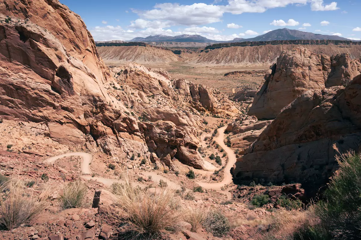
9. Burr Trail Switchbacks
The Burr Trail is a visually astonishing, partially paved route that runs from Boulder, along Scenic Byway 12, to the backcountry of Capitol Reef National Park. It’s one of my favourite places in Utah, because it’s really easy to access, but doesn’t have the visitor numbers that it deserves!
The route passes through Long Canyon, which is this cool, narrow red gorge with a sneaky slot canyon in, then drops down into vast, empty plains which lead to panoramic views of the Waterpocket Fold of Capitol Reef. Finally, as you enter the national park, the paved section ends and the route becomes more isolated and wild, until you hit the Burr Trail switchbacks, which take you down into this beautiful canyon.
Urgh, I just love it, so so much. We’ve driven it at least ten times (probably more), taken backpacking trips down here, explored entirely empty canyons, and more. It’s wild and worth every second you can spare.
The road is totally fine for normal cars, although high clearance is always nice. Do not drive past the switchbacks if it rains, the road turns to clay and you will get stuck.
For more information on other cool things to see nearby the Burr Trail, check out our post on things to do around Escalante.
10. Fisher Towers View
Fisher Towers are a set of odd-looking sandstone spires, not too far outside the town of Moab. There’s a very cool hike you can do around the spires but, here, we’re talking about beautiful spots that don’t involve hiking (although we highly recommend the hike, too).
There is such a cool view of the Fisher Towers from route 128, which leads out north east from Moab along the Colorado River.
The entire of the 128 road is worth driving; it’s probably one of the most scenic paved routes in the entirety of Utah. However, there are certain sections that just pop – like the road section after passing the Fisher Towers junction where you drive adjacent to the Colorado River.
It’s the towers, the Colorado River, the red canyon, little sandy beaches, and snowy La Sal Mountains, all stacked in a perfect panorama.
If this intrigues you, have a look at our three days in Moab itinerary – visiting Fisher Towers is an option on that!

11. Horseshoe Bend from Below
If you’ve done any research into beautiful spots around the southwest, then Horseshoe Bend will almost certainly have popped up. It’s the premier Instagram spot in Page, Arizona, and has been the subject of many a screensaver.
Here, though, we’re offering you an alternative to all the crazy crowds taking the same, boring (but beautiful) photos: consider seeing it from the bottom instead!
There are options to take a boat trip from Lees Ferry, or even kayak the river, which is what we did! Being surrounded by those 1000-foot majestic cliffs, almost completely alone, will become a key memory, I promise. There are even a bunch of campgrounds right at the bottom of the viewpoint, which most people miss when taking their Insta-selfies at the top.
If you want to have a read about our experience, we’ve written in detail about how to see Horseshoe Bend via kayak.


12. Goblin Valley
Okay, I know I said I wouldn’t include entire parks, but this one is a bit different.
In theory, Goblin Valley could be (and should be?) crowded, yet it rarely is. It’s a vast arena full of melting hoodoos, with views that extend for miles. The best part? You can hike wherever you want and climb whatever you want. It’s the perfect adventurer’s playground, in a remote region to the east of Capitol Reef.
We’ve visited a bunch of times and camped twice in the park’s campground (it’s absolutely magnificent and our favourite campground in Utah). Goblin Valley is such a special, unique, and remote place.
It’s the light that makes this park extraordinary, especially in the evenings when the sun is low, creating long, goblin-esque shadows everywhere. For a different perspective, head away from the famous hoodoo fields past the Carmel Canyon Trailhead and the scenery changes, with these huge outcrops that catch the light perfectly. It’s magic.
Nearby Goblin Valley is the epic Little Wild Horse and Bells Canyon hike. We highly recommend doing this one while you’re in the area, if you can – it’s epic.


13. Bryce Canyon Amphitheater
I think this is the only potentially busy entry on this list – because Bryce Canyon is undeniably popular, but you can’t not include it when you’re talking about unique, photogenic spots around southern Utah.
It has the world’s largest concentration of hoodoos, giant irregular spires of rocks that glow a rusty orange-pink in the sunlight.
I was thinking about which bit of Bryce Canyon was the prettiest and was torn between the main amphitheater, the lonely, cliffside bristlecone trees at the furthest end (my fave), the waterfall at Mossy Cave, or maybe even the perfectly positioned natural bridge halfway up.
At the end of the day, though, the amphitheater won. It’s magnificent and usually not too busy outside of the peak summer season (people don’t hang around Bryce for very long because it’s small, so if you stay overnight in the area, you can usually find loads of quiet spots to watch the sunset).
I prefer to hike around the ancient bristlecones, because it’s desolate and empty, but the scenery is just as magnificent in the popular bit of Bryce, so maybe visit both!
For more to do around Bryce Canyon, have a look at our Scenic Byway 12 guide.

14. Green River and Candlestick Tower Overlooks
These overlooks are just a few of many within the Island in the Sky district of Canyonlands National Park.
This park is my favourite of the five national parks in Utah, with relatively low visitor rates and an enormous amount of space. The ‘population density’ of this park is so low that, unless you visit at peak season and go to the few popular spots, you’ll find loads of quiet, peaceful space.
The entirety of this national park is visually superb, offering vistas from all angles but several no-hike places stand out – Green River and Candlestick Tower overlooks. They’re both nearly adjacent to each other on the western side of the mesa, with magnificent views of the Green River, the White Rim, and Candlestick.
Candlestick Tower overlook is a particularly magnificent place to watch at sunset.
For more photo spots and places to visit in Canyonlands, take a look at how we’d spend one perfect day.


Car Hire for your Utah Trip
We always rent our vehicles all over the world, including our recent trips in the United States, Thailand, Malaysia, Oman, Saudi Arabia, Tunisia, Jordan and Morocco, with Discover Cars. They’re often the most affordable, plus they paid out immediately on an insurance claim we made when our car took some heavy damage in Sicily. We fully recommend them.
–
TAKE A LOOK BELOW OR CHECK CAR RENTAL
Locations with Some Hiking
15. Skull Arch in the Fiery Furnace
This sneaky but scenic arch is hidden within the fins of a permit-only area of Arches National Park. There are very few permits available per day so, for the most part, you’ll be able to wander around this epic rocky adventure all alone if you get one!
The entire area of Fiery Furnace is incredible, but my favourite spot was Skull Arch, a huge double arch that towers over the narrow channels and kind of looks like eyes staring down at you. It was very, very cool.
This area does involve some route-finding, which makes finding the arch a little more challenging than the average hike, but it’s not hard (I mean, I managed and didn’t die, and I’d hardly call myself a competent outdoors-person).
For more information on permits, the hike and fees, check out our dedicated Fiery Furnace guide.
Hike length ~ 3 miles, moderate, with scrambling


16. Kanarra Falls
Kanarra Falls is a permit-only hike nearby Zion National Park. In fact, it’s a kind of quiet equivalent to Zion’s famous Narrows hike!
The trail follows the Kanarra Creek into a tight canyon with several waterfalls. The entire route is a really pretty hike but, If I had to choose, I’d say that the tight slot section before the first waterfall and the section right at the end near waterfall three are the prettiest.
It’s just a very, very photogenic little section of southern Utah.
You’ll actually walk through the river for significant portions, so ensure you are cognizant of how cold the water is and wear sensible shoes and clothes.
For more information, including permits, safety and fees, check out our Kanarra Falls hiking guide.
Hike length ~ 4 miles, moderate, through water


17. Angel’s Palace in Kodachrome Basin
This trail is located in Kodachrome Basin State Park, on Scenic Byway 12, not far from Bryce Canyon National Park. It’s an underrated, compact park, full of red spires, scenic viewpoints, and hardly any visitors!
The campground is one of the nicest in the Utah State Parks system, too, with amazing hot showers and heated bathroom blocks!
My personal favourite hike in the park is Angel’s Palace, which leads up through the red rocks to a bunch of ledges that overlook the park. The views are absolutely spectacular and really unique to this particularly colourful park.
Hike length ~ 2 miles, moderate

18. Buckskin Gulch
Buckskin Gulch is thought to be the world’s longest slot canyon, which, on its own is a pretty cool stat and made me want to visit. The thing is, it’s also no doubt one of the prettiest, too.
Located down a dirt track between Page and Kanab that stretches south into Arizona, Buckskin Gulch is actually located really close to the famous Wave (in fact, they have the same trailhead!). The road is suitable for any car, technically, but we were happy to have a high clearance AWD. There have always been plenty of sedans in the car park when we’ve visited, so as long as it doesn’t rain, you’ll be fine.
You may be asking – is it really prettier than Antelope Canyon, and why isn’t Antelope Canyon on this list? Well, it’s because I don’t rate the experience at Antelope Canyon, at all. Especially not if you are a photographer. Buckskin Gulch is a natural work of art, with very reasonable fees and barely any crowds.
If you’re interested, I’ve written more about why I rate Buckskin Gulch over Antelope Canyon for photographers.
Hike length ~ between 4-24 miles, moderate


19. Toadstool Hoodoos Viewpoint
The Toadstool Hoodoos trail is a short, family-friendly hike between Page and Kanab, with some weird looking mushroom hoodoos at the end. The hike is quite nice for the effort you have to put in, but for me, the highlight was the vast, scenic red and white views over the Rimrocks that nobody talks about.
Right at the end, once you reach the toadstool rocks, take a left and explore towards the cliff edges. The views are like an expansive rainbow, far prettier than this super easy trail deserves to be!
The hike is short, so sometimes it can feel a little busy, especially if you visit midday on a weekend. Get there early and you’ll likely have the entire place to yourself, though.
For more information on the trail, have a read of our Toadstools guide.
Hike length ~ 1.5 miles, easy

20. Zebra Slot
Zebra Slot is just one of a few awesome slot canyon hikes along Hole-in-the-Rock Road, near Escalante, along the Scenic Byway 12. This area is home to some of the coolest (and tightest) accessible slot canyons in Utah.
We choose Zebra because I’m too claustrophobic to hike the tighter, narrower ones, like Spooky and Peekaboo (and it turns out that Zebra is crazy tight, too, but at least it’s short so terrified me less!). Luckily this hike is not popular and the road to reach it is a washboard nightmare, so there are very few crowds – only one person can fit each way through the slot anyway!
The hike is as much a highlight as the slot canyon itself. The scenery gets progressively more interesting, the further towards the canyon you get, although there’s some serious sand hiking along the way (which is just the worst, right?).
For more awesome slot canyon hikes, take a look at our favourites.
Hike length ~ 5 miles, moderate, with sand, difficult to navigate the slot


21. Owachomo Bridge in Natural Bridges
Natural Bridges National Monument is empty. I mean, if you’re (un)lucky, there might be a couple of people in the campground and a few driving the loop road, but you’re not likely to bump into them! It’s a crazy remote, beautiful park just off the isolated State Route 95 (the same road as the Hite Overlook, mentioned above).
The park has three, utterly enormous natural bridges: Sipapu, Kachina and Owachomo. These bridges are some of the largest in the world and are awesome, whether you choose to hike beneath them or spot them from the viewpoints.
Our favourite was Owachomo – it’s such a cool, easy little hike and weirdly easy to photograph (sometimes they can be a little awkward!).
Hike length ~ 0.5 miles at minimum, easy but with some stairs

22. Joint Trail, Needles
The Joint Trail is part of the Chesler Park section of the Needles District in Canyonlands National Park. This region is pretty remote and takes a solid 90 minutes or so to drive from Moab, the nearest larger town.
However much effort it is to get to the Needles District though, it’s absolutely worth it. Chesler Park is one of the most beautiful (and fun) places I’ve ever backpacked, and the Joint Trail is the coolest bit of that route!
It’s a strange, constricted section that follows through fractures and caverns within the rocks. The trail feels like an odd selection of narrow slot canyons and caves, which are often sort of square and abrupt. I’ve never hiked anywhere else like it in the world – it’s weird and unique (in a good way).
My pictures are a bit old and taken on a phone, but we’d highly recommend you check it out – it’s definitely up there as one of the most beautiful spots in the state.
Hike ~ 10 miles, hard due to the length and varied terrain


23. Moses and Zeus
This is the first truly tricky spot to reach on this list (without a four-wheel drive, anyway). It’s located in Island in the Sky, Canyonlands, and the trailhead is reached by the permit-only four-wheel drive White Rim Road, or a lengthy hike with a chunky 1500 feet of elevation change.
It’s worth it, though – you get to scramble up these iconic spires, named Zeus and Moses. The hike up them is reasonably easy (700 feet of elevation gain) and is insanely scenic, providing vast views of the almost symmetric Taylor Canyon, which leads down to the banks of the Green River.
Apart from getting savagely sunburnt, I absolutely loved this little hike – the vistas are almost unmatched, and the chances of you seeing another soul on the trail is very, very low.
Hike ~ 11 mile round trip to the trailhead, then 1.3 miles up to the spires, very difficult


24. Delicate Arch
I feel a bit bad about putting this one on the list, because it’s basically the most popular hike on the planet – Delicate Arch is literally on the Utah license plates! It’s world famous, so people are obviously going to hike it. We did it, even though we hate crowds and would normally do anything to avoid them.
It’s incredibly popular, so why did we include it?
Well, it’s kind of scenic, isn’t it?
Plus, it isn’t always busy. We hiked it at sunrise, and it wasn’t awful. I’d say that the hike itself is pretty uninspiring, mostly just trekking up tedious slick rock. However, if you get there early, you can take your photo without having to wait (seriously, there’s often a giant queue), and get out without too much drama.
Also, getting there earlier avoids the crazy hot, exposed hills.
If you’re sat here planning a trip with time restrictions and wondering if Canyonlands or Arches is better for your itinerary, have a look at how we’d visit both in one day.
Hike ~ 3 miles, moderate, hard in summer due to sun exposure

WANT TO TAKE A BETTER TRAVEL PHOTO?
There are three parts to travel photography –
◊ Planning your trip
◊ Taking the photo
◊ Editing the end result
To get the highest quality, most sophisticated photos from your travels, you’ll need to perfect all three (plus a tiny bit of luck).
So, we’ve written a lot of country-specific guides about planning trips to various destinations, and also collated our absolute top tips for taking photos on location. We’ve also written a dedicated post on how to take the best black and white travel photography. Check them out if you’re interested!
We also write about typical editing mistakes to avoid. To complement that, we’ve collated a more intermediate user’s guide to editing travel photography. This covers more elegant, advanced and refined skills, ones that will promote your photos to the centerpiece of anybody’s wall.
–
25. Sunset Point, Capitol Reef
This spot is pretty low key – just a nice little unremarkable viewpoint in Capitol Reef National Park. I loved it because the scenery there is colourful and dramatic, especially if you have some moody weather, like we always seem to when we visit.
As with many places in Capitol Reef, if you’re lucky, you’ll be the only ones there, hanging out in nature watching the sunset. Is there anything better?
The walk is super simple and probably the easiest on this list – if you’re in Capitol Reef, it’s a must do! Also, take a look at how we’d spend a perfect day there, if you’re planning a visit.
Hike ~ less than a mile, easy

26. Escalante Natural Bridge
This spot is niche.
If you’re looking for an easy, extra scenic river hike that leads to a super picturesque natural bridge and a small arch, all surrounded by native American cliff dwellings on giant red canyon walls, then you’ve found your ideal one.
It’s located a few miles outside of the tiny town of Escalante on Byway 12 and, apart from the cold water, is an absolutely incredible find.
We had to cross the river a whole load of times (so prepare to get your feet wet), but you don’t have to walk continuously through it, so it’s not too bad. The hike is also mostly flat.
The Escalante Bridge itself is magnificent, set within a mini canyon. Don’t forget to hike behind it for the best photo angles (depending on the time of day and sun position).
Hike ~ 3.2 miles, easy but with river crossings


27. Calf Creek (Upper and Lower)
Calf Creek is a long gorge that runs parallel to the Scenic Byway 12, a little north of the town of Escalante.
There is a creek that runs through its base – resulting in several waterfalls that you can hike to. The most popular (and busy) is Lower Calf Creek Falls – it’s pretty Insta-famous at this point (for good reason – it’s pretty and the walk is easy).
The upper waterfall is always almost empty, super scenic, but a little harder to hike to and has a lower volume of water pouring over.
You can choose which you’d prefer (or hike to both!), but we always go with the upper one now when returning, just because the lower is notoriously busy, including the parking. We have written about the lower route if you’re interested in learning more.
Lower hike ~ 6 miles, easy
Upper hike ~ 3 miles, moderate, difficult in summer due to sun exposure and steepness


28. Murphy Point
This might be my all-time favourite spot in Canyonlands National Park, and it’s not even an enormous slog down to the White Rim. Murphy Point has definitely got the best backcountry campsite views for effort ratio: it’s spectacular.
Honestly, it makes the Grand Canyon look dull (just to be clear, I do not actually think the Grand Canyon is dull. In fact, I’m mildly fanatical about it).
The hike is almost flat and straight, and leads right out to a cool, rocky precipice where you can wild camp anywhere you want (permits required). It’s one of the most beautiful places I’ve ever put up a tent.
You can hike out without a tent, obviously, but it’s so pretty at sunset we’d recommend coming later in the afternoon and bringing a head torch in case it’s a bit dark on your way back. Be careful, because at the end there is no path (it’s mostly slick rock), so make sure you know how to get back if the light goes.
Hike ~ 3.4 miles, easy


29. Kanab Sand Caves
The Kanab Sand Caves are a weird one. They’re these strange, manmade caves set up in the red cliffs, just a few miles outside the little town of the same name.
They’re kind of basic – right on the road and you can see them from the car as you pass by. Yet, somehow, these simple little caves with sandy floors are kind of photogenic. Unreasonably so, I’d say!
The caves are really easy to reach, too, with a short walk from a dedicated car park, then a tiny scramble up a very easy-to-climb ‘cliff’ (for lack of a better word).
If you’re interested in visiting these quirky little features, have a read of our little guide.
Hike ~ 1.2 miles, easy


30. The Navajo Knobs
This is a magical spot, exhibiting everything that is beautiful about southern Utah – views of dramatic red cliffs, old pioneering villages and distant winding roads.
It’s the hardest and highest front-country hike in Capitol Reef. The climb takes you thousands of feet up to these cool rock formations called the Navajo Knobs, which are right at the top of these gigantic cliffs. There is a bit of scary (if you’re me) scramble to the literal peak, but you don’t have to do it if you’re not keen. I managed, so any vaguely competent person can, too.
Sitting atop the Navajo Knobs really shows off how scenic this park is (my photos are a bit old and do not do it justice!). I wholehearted recommend this hike to anyone who is mildly fit and has some time spare in Capitol Reef.
For more ideas on what to do in Capitol Reef (including some easier hike suggestions!), have a look at our one-day itinerary.
Hike ~ 9 miles, strenuous due to elevation change of 1600 feet


31. The Wave
I have, sadly, never managed to get a super-competitive permit for the Wave, despite hundreds of applications and nearly a year spent in southern Utah. It’s just unfortunate.
The Wave is up there with Horseshoe Bend and Antelope Canyon in terms of popularity because it’s so strikingly beautiful, and there are so few permits available that if you get lucky, you’ll have a lovely quiet hike to one of Utah’s most beloved spots. It may be popular but it definitely counts as crowd free!
So, I’ve included it here in case you want to apply for a permit before your trip.

Some Other, More Difficult Spots
We are tourists in the United States, not residents, which means we do not have a four-wheel drive with good insurance that we can trash on crazy off-road trails!
Our cars are always rentals, so we cannot go anywhere too crazy. If you’re in the same situation as us, then the list above is for you. However, if you do have access to a rugged four-wheel drive monster or want to take a tour, then consider visiting some of the beautiful spots below, too:
⬩ Cosmic Ashtray (outside Kanab)
⬩ White Pocket (between Kanab and Page)
⬩ Bentonite Hills (Hanksville)
⬩ Far end of Hole-in-the-Rock Road (Escalante)
⬩ Red Canyon/Peekaboo Slot and Great Chamber (Kanab)
⬩ Alstrom Point (Page)
⬩ The White Rim (Canyonlands) – you can hike to this, we’ve done it a few times
Many of these are partly okay in an AWD/high-clearance, but we wouldn’t recommend it in a rental unless you’re not worried about voiding your insurance. Pretty much all of these routes should be avoided in the rain.


Map of Southern Utah’s Best Spots
Below is a savable Google Map which marks all the places on this post.
To save the map, select the star next to the title.
HAVE WE HELPED YOU PLAN A TRIP IN SOUTHERN UTAH?
If you’ve found our content helpful, consider booking your rental car (if you need one!), through the company we always use – Discover Cars. They’re the absolute best and have been our rental companion (and saviour, thanks to their insurance) in many destinations across the world.
Also, consider booking your accommodation through Booking.com – we use them exclusively when travelling in North America.
Help like this makes it easier to pay for the upkeep of this site. Thank you!
–
Where to Next?
If you’ve made it to the bottom of this marathon list then we applaud you!
These locations are just a tiny taste of what southern Utah has to offer – there are all the traditional spots within the national parks and all the typical Instagram spots, too, plus more. Everything is beautiful here!
However, we highly recommend spending time in the quieter parks and monuments, even if you’re short on time, because that’s where Utah’s magic is most apparent – it’s found in the hushed, quiet moments, in my opinion.
If all of these places have appealed to you, have a look at our southern Utah road trip Itinerary (map below) which includes every single spot on this list. It plots the ideal way to plan a whole trip, including the major national parks, too.
I hope you have a beautiful trip!

Hi, thanks for visiting our blog! If our free content has been of help to you, or you’ve just enjoyed our random ramblings and musings, say thank you by buying us a coffee! It helps keep The Restless Beans blog up and running.
Thank you, Claire + Nick


