10 Quirky Things Around Monument Valley to Avoid the Crowds (and an Itinerary)
Scribbled by Claire ◊ 26 Jul 2024
Are you planning a trip to see the iconic Monument Valley, but are wondering if there’s anything else to do in this remote corner of Utah? Well, there are loads of cool and quirky things, including lots of off-beat locations that avoid the crowds! We’ve also written a Monument Valley itinerary that plans out the perfect route through them all.

Monument Valley is the posterchild of the American southwest, synonymous in pop culture with cowboys and the ‘Wild West’. It’s one of those overwhelming, iconic moments, looking out over the distinctively recognisable, 1000-foot-high buttes and the vast, auburn desert landscape.
However, did you know that there is far more to do in the region than just check out the Monument Valley Tribal Park itself? The area is packed with beautiful things to do and see, whether you’re a film fan, outdoors enthusiast or just passing through as part of a southwest road trip.
We’ve visited Monument Valley and the surrounding region at least six times now, in each instance gaining a greater understanding of the area and all the incredible things to do. There are so many places that often get missed, like record-breaking bridges at nearby Natural Bridges, the sinuous San Juan River at Goosenecks, secret picnic spots behind Mexican Hat, and remote drives through Valley of the Gods, plus so much more.
These sights are ideal for enhancing a longer road trip around Utah and Arizona, whether you are arriving from Moab, Page or even further away, and they can all be combined to create an epic, varied and less-visited itinerary around one of the most exciting outdoor destinations in the world!

IN THIS GUIDE //
Offbeat adventures around Monument Valley
WHERE IS MONUMENT VALLEY?
1. DRIVE THE MONUMENT VALLEY LOOP
2. THE MOST FAMOUS VIEWPOINT
3. MOKI DUGWAY
4. MULEY POINT
5. VALLEY OF THE GODS
6. NATURAL BRIDGES NATIONAL MONUMENT
7. MEXICAN HAT
8. GOOSENECKS STATE PARK
9. NAVAJO NATIONAL MONUMENT
10. HOVENWEEP NATIONAL MONUMENT
TWO DAY ITINERARY
ITINERARY – MAP
WHERE TO STAY
FINAL THOUGHTS
This post may contain affiliate links. If you book through these links we may make a small commission at zero cost to you. It helps us pay for the upkeep of this blog. Thank you!
Where is Monument Valley?
Monument Valley sits directly on the eastern section of the border between Arizona and Utah, on part of the Navajo Nation Tribal Lands. It’s around 2.5 hours from Moab, Utah, and two hours from Page, Arizona – two of the more popular road trip stops in the area.
The park follows MST time and also obeys daylight saving time. This means if you are visiting from Arizona, there may be a time change. Bear this in mind if you book any tours or excursions!

1. Drive the Monument Valley Loop
Although most people visit Monument Valley and only see the visitor centre and famous viewpoint, the highlight here is definitely self-driving the adventurous 17-mile road around the soaring, burnt-orange buttes and impressive cliff landscapes. It’s one of my favourite moments on our most recent trip.
The Monument Valley Loop is a sandy, unpaved road, which can get a little rough. Consider whether you would be happy driving a rental car or low clearance vehicle down there. If you are not, there are lots of open-air jeep-style tours with local guides that you can join when you arrive. These cost around 80-100 dollars per person for 2-3 hours (we’ve actually seen some very reasonably priced ones on Get Your Guide if you’d like to prebook).
This is a pretty costly tour if you are travelling as a group or family, so we’ll write more soon with specific details on self-driving it in a dedicated post on driving around Monument Valley (including our experience of the road conditions and car requirements).
If you’re still unsure if you’d like to self-drive the loop with a normal clearance car – we did see a Mustang down there – so it’s definitely possible!
Fees | $8 dollars per person
Distance from Monument Valley | 0
Road conditions | paved and dirt roads
Opening hours | 8am-5pm winter, 7am-7pm summer
Time needed | 2-4 hours
◊

2. Take a Picture at the Famous Viewpoint
Forrest Gump Point is probably the most famous view of Monument Valley, (outside of the park itself, anyway).
It’s located outside the park, just north of the Monument Valley entrance on US Route 163 (so no fees). Google Maps has the location marked accurately. It is famous for, you guessed it, a scene from the 1994 film of the same name.
Typically, you’ll see people leaping out into the road all over the place to get the perfect Monument Valley picture (we’re slightly guilty of this a few years ago, too). If you do this, be extra careful of fast-moving traffic. This is a great viewpoint if you don’t want to pay to enter the park proper (although we think it’s really worth the entry fee to drive the loop road).
Tip | at Forrest Gump Point, if you walk up to the left of the point (off the road), there’s some small, raised areas where you can get nice pictures and not be run over by a giant truck or distracted tourist. Also, first thing in the morning has the best light and smallest crowds.
Fees | 0
Distance from Monument Valley | 15.5 miles
Road conditions | paved roads
Opening hours | n/a
Time needed | 20 minutes
◊

3. Ascend the Moki Dugway
The three-mile Moki Dugway (on Utah Highway 261) is a particularly scenic, easy-to-drive gravel road northwest of Monument Valley. It is well-known for its switchbacks, which are cut directly into an especially steep, 1200-foot cliff, which are part of a longer road connecting the Utah Route 95 with the US Highway 163.
The road itself is suitable for any car (we’ve driven it in a low clearance sedan with no issues), although I’d avoid it after heavy rain.
From the top on Cedar Mesa, there are epic views across to Valley of the Gods, Monument Valley and even the distinctive Shiprock, New Mexico in the distance (so I’m told – I’ve never managed to spot Shiprock from up there!). Try to visit on a clear, sunny day (I’ve been up there a few times in the cloud and it’s a pity for the view to be so obscured).
Apparently, the distinctive name is from the Ancestral Puebloans, who dug handholds into the cliffs called ‘Moki steps’, plus ‘dugway’, which is the name for a road cut into a hill or cliff.
Fees | 0
Distance from Monument Valley | 36 miles
Road conditions | easy dirt roads
Opening hours | n/a
Time needed | 20 minutes
◊

4. Max Out Your Vista Quotient at Muley Point
Just at the top of the Moki Dugway, nearly 6000 feet up, is a small dirt road with basically no signage leading to a magnificent area with views for miles and some absolutely epic camping. The entire cliffside area has outrageous panoramas of Goosenecks State Park and the San Juan River, plus was mostly empty each time we visited.
This area can be reached by following Muley Point Road (no signage) for about 5 miles. It is marked as ‘Muley Point East’ and ‘Muley Point’ on Google Maps (both points are worth checking out). The route is an unmaintained dirt road and, although flat, it would be best to take an SUV style car if possible. Definitely do not go down here in the rain!
The region is super remote and there are no services, so go prepared.
Fees | 0
Distance from Monument Valley | 41.5 miles
Road conditions | moderate dirt roads
Opening hours | n/a
Time needed | 30 minutes
◊


5. Get Lost in the Valley of the Gods
Valley of the Gods is magic.
It’s just like a more spread-out Monument Valley, with no fees or permits, some outstanding BLM camping, a few bathrooms and pretty much nothing (and nobody) else. There are sandstone monoliths and enormous rock formations, all named after what they kind of look like – ‘Lady in the Bathtub’, ‘Setting Hen’ and ‘Rooster Butte’ to list just a few.
There is one 17-mile, unmaintained, unpaved loop road meandering through the area, which is not too awful to drive. We visited on a particularly sunny, dry day, and still had to take sections of if slowly in an AWD high clearance vehicle. However, you could possibly get by in a sedan (people always seem to somehow manage it, but I wouldn’t take a low clearance rental). I also wouldn’t give this road a try in any car after a lot of rain.
The worst part of the road is around the apex in the middle, near 37.312554, -109.857230, so you could drive as much of it as you feel comfortable with, then turn around.
There are two entrances – one right next to Moki Dugway and the other on Highway 163, marked as ‘Entrance to Valley of the Gods Rd’ on Google. There are portaloos at either end.
For a deep dive into the ultimate battle, check out our Monument Valley vs. Valley of the Gods post.
Fees | 0
Distance from Monument Valley | 36 miles
Road conditions | rough dirt roads
Opening hours | n/a
Time needed | 2-3 hours
◊

6. Be Wowed at Natural Bridges National Monument
It took us an extraordinary amount of time to finally make it to Natural Bridges National Monument, and I’m glad we finally did. It’s a beautiful little park and Utah’s first national monument, hidden up off Route 95 (a road full of panoramas that should be driven in its entirety – there are many wonderful things to see there including slot canyons, some cool bridges and access to the Colorado River).
National Bridges National Monument is a great place to learn what the distinctions are between natural bridges and arches (this took me an unreasonable amount of time to remember – it basically depends on how they are eroded). There are three imposing, colossal bridges (named by the Hopi as Sipapu, Kachina and Owachomo) at this park with some nice easy canyon hiking to reach each one (and some cool viewpoints if you don’t want to walk).
Fees | $20 per vehicle, or free with America The Beautiful pass
Distance from Monument Valley | 65 miles
Road conditions | paved
Opening hours | 24 hours
Time needed | 3 hours (depending on if you hike)
◊

MONUMENT VALLEY NAVAJO TRIBAL PARK – QUICK FACTS
Name in Navajo – Tse’ Bii’ Ndzisgaii (means ‘Valley of the Rocks’)
Area – 92,000 acres
Entry Fee – $8 per person
Opening Hours – winter: 8am-5pm, summer: 7am-7pm
Number of John Ford movies filmed here – 9
First movie –The Vanishing American (1925)
Visitors per year – 400,000+
Park created – 1960
Elevation – 5564 feet
Drones – not allowed anywhere on the Navajo Nation
–
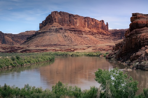
7. Picnic Under Mexican Hat
Mexican Hat is a tiny settlement on the San Juan River, 30 minutes northeast of Monument Valley. It is also the name of a distinctive 300-foot-tall formation called Mexican Hat Rock. It turns out that the town is named after the Cedar Mesa sandstone rock – which vaguely resembles a sombrero (so they say!).
The quirky town is absolutely tiny but has a few hotels and restaurants, plus access to the San Juan River. However, people often visit here purely to see (or even climb – fun fact, it was first climbed in 1962) the landmark rock.
It’s possible to see Mexican Hat Rock directly from the main road, so you don’t even need to stop. However, if you’d like to explore, we’d recommend driving behind the rock (pretty rough dirt roads) and eventually, you’ll reach the banks of the San Juan River at 37.170961, -109.837056, in a remote location that you’ll likely have all to yourself. It’s perfect for a picnic.
Fees | 0
Distance from Monument Valley | 23 miles
Road conditions | easy dirt roads
Opening hours | n/a
Time needed | 10 minutes
◊


8. Spot the Wiggles at Goosenecks State Park
Goosenecks State Park is so named because of the sinuous shape of the canyons that have been gradually carved out by the San Juan River over 300 million years. The river is so twisty that it flows six miles, to travel only 1.5 miles as the bird flies! It’s quite distinctive (and is also easily seen from Muley Point, mentioned above).
This park is very close to Moki Dugway, Muley Point and Valley of the Gods, making it a perfect lunch/afternoon stop off on the way to or from them. The nearby Honaker Trail gives great, closer views of the San Juan River (a tiny bit like Horseshoe Bend, minus the enormous crowds). The trailhead is awkward (turn left at the white water tank thing off Johns Canyon Road) and requires high clearance.
Another option is to take a drive down Johns Canyon Road for more Gooseneck views – a dirt road that I’d avoid during wet weather.
Fees | $5 per vehicle
Distance from Monument Valley | 31 miles
Road conditions | paved
Opening hours | 24 hours
Time needed | 30 minutes
◊

9. Hike to Ancient Cliff Dwellings at Navajo National Monument
Navajo National Monument is one of my favourite native American sites in the region. Located in the Navajo Nation in northern Arizona, there are three remarkably well-preserved native American cliff dwellings, build by the Ancestral Puebloans in the 13th century. Set on a high plateau, there are panoramic views over, and ranger-led hikes into, an impressive canyon (which we saw all magically covered in snow – be careful, it’s so slippery!).
The main overlook provides an astonishing display of one Native American cliff dwelling, with an implausibly circular alcove surrounding the settlement, which is concealed underneath the huge, arched cliff.
Keet Seel (‘broken pottery scattered around’ in Navajo), the larger site and deemed one of the best preserved Native American Ruins in the entire of the southwest, is not viewable from the rim but ranger-led tours of the Betatakin site are available (strenuous).
Fees | 0
Distance from Monument Valley | 54.5 miles
Road conditions | paved
Opening hours | 24 hours
Time needed | 30-60 minutes
◊

10. Avoid the Rattlesnakes at Hovenweep National Monument
Hovenweep National Monument is a little further away than the other entries on this list and is pretty remote.
We quite liked it as it’s not heavily visited and pretty interesting, so thought it was worth mentioning. Plus, almost all the sites on this entire list are spread across Native American land, so it’s worth spending as much time as possible learning about the ancient and living history of the region. For more ideas of places to visit like this, check out our post about native sites across the southwest.
Hovenweep, built by ancestral Puebloans, was once populated by more than 2500 people and consisted of six ancient villages. The towering remains, mostly built between CE 1200-1300, are rested around the edges of beautiful canyons that you can hike across as parts of the park.
There is also a particularly good visitor centre and campground here. Be careful of rattlesnakes – we came across so many and I still have nightmares about it when I hear rattling noises!
Fees: $20 per vehicle, or free with America The Beautiful pass
Distance from Monument Valley: 90 miles
Road conditions: paved
Opening hours: 24 hours, trails open from sunrise to sunset
Time needed: 1-3 hours
◊

A Monument Valley Itinerary
If I were to combine all these sites into several days for a road trip itinerary (I don’t think you could do it comfortably in one day), below is how I’d do it.
It’s a pretty packed, driving-intensive schedule (in the direction from Moab to Page – but you could easily reverse this). It would definitely be possible to add a day or two more in Bluff, Mexican Hat, Kayenta or Monument Valley to slow things down a little and take a longer weekend in Monument Valley.
Day 1
◊ Overnight at Blanding (maybe spend the previous day in the Needles District of Canyonlands if you can – it’s relatively nearby and is also spectacular and one of my favourite places).
↔ 45 mins drive
◊ Drive to Natural Bridges. Spend the morning (3 hours, less for only viewpoints, more if you want to hike a lot).
↔ 45 mins drive
◊ Drive to Muley Point via Moki Dugway. Check out the views and have a packed lunch (30 minutes).
↔ 25 mins drive
◊ Enter the Valley of the Gods loop beginning at the bottom of Moki Dugway, exit at the other end (2 hours).
↔ 10 mins drive
◊ Head over to Goosenecks for late afternoon and have a snack (20-30 minutes).
↔ 20 mins drive (via Mexican Hat)
◊ Forrest Gump Point via Mexican Hat (10 minutes – longer if you hang out by the river) – get some classic sunset pictures (20 minutes).
↔ 20 mins drive
◊ Stay near Monument Valley/Goulding’s. Another option is to stay at Mexican Hat or Bluff.
Dinner: grab something locally or go to the supermarket in Goulding’s. Other people highly recommend the Goulding’s Stagecoach Dining Room, but we didn’t rate our meal at all when we stayed there. The only really decent food we’ve eaten in the area is at Amigo Cafe, down in Kayenta. There aren’t many veggie options on the menu, but the three sister’s burrito, chile relleno and fry bread with ice cream are always pretty decent.
Day 2
Grab breakfast in your accommodation near Monument Valley. Early morning, maybe take some extra photos at Forrest Gump Point if you were late the previous evening, then head into the Monument Valley Tribal Park and drive the loop (2-4 hours).
↔ 60 mins drive
◊ Drive to Navajo National Monument (30-45 minutes to see the viewpoint, most of the day if you plan to do the ranger-led hike).
↔ 80 mins drive
◊ Head to Page for the evening (or wherever you next destination is).
Note | to add in Hovenweep National Monument, I’d recommend taking an extra day and visiting it from Blanding (1 hour drive).

Itinerary Map
Below is a savable Google Map marking all the things to do in Monument Valley mentioned in this post. It also shows the itinerary route, too.
To save the map, select the star next to the title.
WHERE TO STAY NEAR MONUMENT VALLEY
There are several options for accommodation nearby, including Monument Valley itself, Gouldings, Kayenta, Mexican Hat and, slightly further out, Bluff. Most options out here are kind of expensive for what you get, but the below are the best of the bunch.
We’ve stayed in all these towns over the years, so below are our hotel recommendations for each area:
Monument Valley | The View Hotel or The View Hotel Cabins (there is also a camping option). These have the best views of the Mittens and Garrick Butte, but come at an extreme price for the room quality. Don’t be sucked in by the good view.
Goulding’s Lodge | this is just opposite the entrance to Monument Valley, so is in a perfect location, with a pretty setting in the opposite cliffs. We actually stayed in a cool little cabin in the campground that we absolutely loved (we were supposed to camp but it was snowing). Check availability at Goulding’s Lodge.
Kayenta | this is a larger town south of Monument Valley and has some traditional motel options, the best being the Hampton Inn Kayenta Monument Valley. It’s a decent, modern motel, but pricey.
Mexican Hat | this tiny, quirky little town is a bit of an experience. It would be my least favourite choice to stay, but if you do, we recommend Hat Rock Inn (recently renovated) or the San Juan Inn (super friendly). They are the best of the bunch.
Bluff | this wild west, Navajo outpost style town has a few decent options for accommodation, by far our favourite being the Desert Rose Resort and Cabins. It was surprisingly pleasant for the area and definitely one of the nicest places on this list.
Blanding | an unassuming town, with a few decent accommodation options. Out of the three motels we’ve stayed at, Stone Lizard Lodge is by far and away the winner. It’s got cute decor, a decent breakfast and the price is perfect for what you get.
For accommodation suggestions further afield, check out our Moab guide or our Page guide.
–

CAR HIRE FOR YOUR SOUTHWEST ITINERARY
We always rent our vehicles all over the world, including our recent trips across the United States, with Discover Cars. They’re often the most affordable, plus they paid out immediately on an insurance claim we made when our car took some heavy damage in Sicily. We fully recommend them.
–
TAKE A LOOK BELOW OR CHECK CAR RENTAL
Final Thoughts
Even after many road trips to the Navajo Nation, I never get bored coming here. This region, although heavily visited by tourists, is only minimally explored by most. It provides an ideal opportunity to get off the tourist trail while also experiencing one of the most legendary landmarks in the world.
This Monument Valley list and itinerary is also excellent for anyone trying to get an in-depth experience of the American southwest, one that goes beyond the surface. By spending a little more time in the region, you can explore beyond the buttes, by trying some Native American frybread and traditional buffalo jerky, or shopping for handmade jewellery and art (some is on my wall right now!).
The Monument Valley/Navajo region really is distinct from the rest of Utah and Arizona, both visually and culturally – we hope you have a fantastic trip!
Where to Next?
Now that you’ve seen the best route through Monument Valley’s highlights, take a look at our larger southern Utah road trip. It expands on this post to help you visit all the iconic spots, while adding in loads of off-beat, quirky places you won’t find on standard itineraries.
We’ve also written in detail about Page, Arizona and designed a meticulous three day itinerary in Moab, Utah, too, which are either side of Monument Valley.
Hi, thanks for visiting our blog! If our free content has been of help to you, or you’ve just enjoyed our random ramblings and musings, say thank you by buying us a coffee! It helps keep The Restless Beans blog up and running.
Thank you, Claire + Nick